【データ】
地図は、テキサス大学のWEBサイトから引用。当報告書ではHP貼り付けの都合
で粗く加工しているが、オリジナル画像はきめの細かい優れたものなので、興味のあ
る方はWEBサイトに直接アクセスしていただきたい。ファイルサイズが大きいので
ロードに時間がかかるが、それだけの価値はあると思う。
衛星写真は、イギリスのリモートセンシング会社のWEBサイトから引用してい
る。これもかなり粗く加工した。このサイトは、世界のほとんどの都市を網羅してい
る。衛星写真なのでミクロな分析には適していないが、地上情報の少ないイラクのよ
うな地域には有効である。
・テキサス大学
http://www.lib.utexas.edu/maps/asia.html
・SSTL
http://www.sstl.co.uk/primages/remote_sensing/UOSAT-12/Processed/ut20e-baghdad-msi-rgb.jpg
地上情報は、複数のWEBサイトを参照したが、下記の2件が特に有効だった。当
方は語学に精通していないので誤解(誤訳)箇所があるかもしれないので、オリジナ
ル文面を添付する。なお、サイトの選択は(1)道路建設をする側、(2)その道路
を監視する側の2点で検索した。本来ならば(3)道路を管理する側の調査が手っ取
り早く正確なのだが、アラビア語のサイトを検索する能力がないので回避させていた
だいた。今回は(1)の調査が主で、(2)は一部を確認したが、未だ調査を継続し
ている。NASA、CIAのサイトが有効だが、膨大な英文を解釈するにはもう少し
時間がほしい。(1)においても、建設主体にセルビアの建設会社が関わっているよ
うなので、本当はセルビアのサイトも検索しなければいけないが、今回はある程度検
索先に馴染みのあるアメリカとイギリスに絞った。
<文面は全文ではなく抜粋です。>
・YUーBUILD
http://www.yu-build.com/main/inquiry.html
H - Transport Facilities
EXPRESSWAY No. 1 - Iraq
Construction information
Designed by: Dorch Consult - Consulting Engineers, Munich, Germany Main
Contractor: PZ "Unioninzenjering"Sub-contractors: GP "Planum", "Novi
autoput" and "Mostogradnja" Employer: Ministry for Public Works,
IraqPurpose of the Project: Road traffic Years of Construction: 1979-1983
Project information
THE IRAQI Expressway No. 1 is one of the most attractive roads structures
built in the world in recent years. Super modern road 1,200 km long
connects Kuwait and southern regions of Iraq with the capital Baghdad, with
western regions of Iraq i.e. with Jordan and Syria. § The expressway is
divided in 10 sections that were built by well known construction building
companies from different parts of the world. § The first section, Baghdad
West-Hilla, 101.5 km long was built by three Serbian companies within the
business association "Unioninzenjering". The expressway was built under the
most rigorous technical conditions, in order to ensure a comfortable and
safe drive at maximum speed of 150 km/h and maximum axle load of 16.3 tons.
§ The length of the expressway is 106 km with six carriageways. The
following was built: 15,400,000 m3 embankment, 200,000 m3 concrete layer,
11,000,000 m2 asphalt and asphalt gravel, 240,000 m fencing, 765,000 road
and direction signs, 307,000 m safety signs, 29 km of guardrails, 604
pieces concrete culverts. § GP "Mostogradnja", within business association
"Unioninzenjering", built all the bridge structures on the sections 4A and
4B of the expressway No. 1 in Iraq. On both sections of the highway with
big 100 ps Baghdad-Northe and Baghdad-South and a slip road to the town
of Hilla, there were built 13 structures in the road bed, 29 flyovers and 4
special structures in the loops, of the total area of 74,300 m2. § There
is a special visual characteristical impression of the big flyover in the
loop Baghdad-South, which in the total length of 686 m with the
horizontal circular arc of 300 m branches above the local and international
highway, and thus it has been shown as the symbol of this highway in
numerous designs. In the entire length the road is without expansion joints
and it was built by the method "field to field", with the aid of two
stable, portable scaffolds.
・GLOBAL SECURITY
http://www.globalsecurity.org/military/world/iraq/amarah.htm
Iraq has 38,402 kilometers of paved roads. Expressway No. 1-a 1200-
kilometer, six-lane freeway-connects Baghdad to Kuwait in the south and
runs to Jordan and Syria in the west. A 630-kilometer freeway (Expressway
No. 2) runs north from Baghdad to the Turkish border, where it links up
with the modern freeway connecting southeast Turkey to Ankara and Istanbul.
Another Baghdad-Basra route is planned via Kut and Amarah and will be
known as Expressway No. 3.
今回の報告は予備知識の乏しい地域での暗中模索で、ある意味実験的な報告であ
る。多くの不明点を含めたままで、中間報告と言うべきだろう。今後も調査を継続す
るつもりなので、ミスを見つけた場合や、より明確な情報を入手した場合には追加報
告をする予定である。
当該地域は、東長崎編集部の得意とする地域なので、編集部からの追加情報を期待
している。掲示板の画像は気まぐれで撮影したのかもしれないが、実は相当貴重な情
報になっているのです。
|
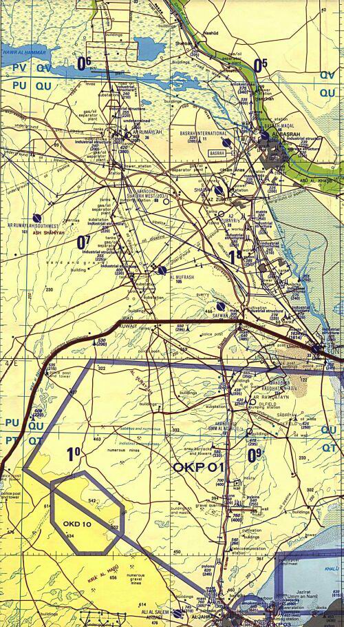 ◆図11
バスラ市およびクウェート広域地図
イラク全土での位置は、図3で確認願います。
◆図11
 バスラ市およびクウェート広域地図
イラク全土での位置は、図3で確認願います。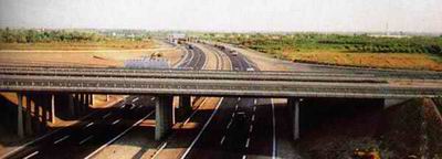 高速1号インターチェンジ部
(yu-build.comのWEBサイトから引用)
 高速1号インターチェンジ部
(yu-build.comのWEBサイトから引用)